HOW TO FIND THE PROPERTY WHEN DOING MY RESEARCH.
Here are some helpful hints on how to find properties available in our Online Land Auction.
For each property listed in the auction catalog, we have provided three things to help you find the property and determine the approximate geographical location: a Google map link; an aerial picture of the property and GPS coordinates which can be entered into Google maps.
TWO SCENARIOS HELPFUL IN FINDING THE PROPERTIES OF YOUR CHOICE:
-
The property has a street address.
If this is the case, finding the property is very simple. Go online to www.maps.google.com and enter the street name and the city/town name. If available, the zip code and the approximate property location will appear. You will then be able to zoom in or out at your convenience until you can clearly tell where the property is located, relative to its surroundings. Once you identify the approximate location of the property, you can compare the detailed view of the property location (from www.maps.google.com) with the plat map (available for each property on www.landauctiondeals.com).
-
The property is in an area with no street signs.
In this case, it is recommended to use GPS coordinates. You can enter these coordinates into www.maps.google.com and as long as you have internet or mobile data access, you’ll be able to find the approximate location of the property. If possible, it is also strongly recommended using a GPS unit (Global Positioning System) to help you find the property location. Basic handheld GPS systems are inexpensive and can be purchased at any major electronics store. Ideally, such a GPS device can be connected to a laptop or handheld device running any of the major mapping software. This will give you a fully functioning, multi-color, interactive GPS system. In this type of system, you would enter the Latitude/Longitude coordinates provided on www.landauctiondeals.com making it easy to find the approximate location of the property. This combination is useful for very large properties not located in a subdivision. The plat maps do not show much of the surroundings, and it would be easy to miss the property otherwise.
UNDERSTANDING THE PARCEL NUMBER SYSTEM.
Most counties, in most states, have a very explicit numbering system to identify the individual parcels and its location in the county. Those numbers in many cases also serve as identifiers for property tax collection purposes.
In Arizona, the Assessor Parcel Number (also called APN) is the single most important identifier of a property. It consists of three sets of numbers XXX-XX-XXX and sometimes also XXX-XX-XXXX (in this latter case the last number is usually a letter). The three parts of each parcel number represent the Assessor’s Book, the Page, and the Parcel. For example: Parcel number 503-90-664B means that this property is mapped in the Assessor’s Book Number 503, on Page 90, and it is parcel 664B on that page.
In California, the numbering is similar, but there is a slight difference between the Assessor’s Parcel Number and the Assessor’s Tax Number (in Arizona the same number is used for both). To find a property on a Parcel Map, look for the last set of numbers on the parcel number and find it in the Parcel Map attached to each property listing. For your convenience, on each Parcel Map, the parcel to be sold at auction has been identified on each of the plat maps.
LOOKING AT A PARCEL MAP AND/OR THE SHORT LEGAL DESCRIPTION, HOW DO I FIND OUT WHERE THIS PARCEL IS IN RELATION TO OTHER PARTS OF THE COUNTY, STATE, USA?
Several methods of description are used in the United States: (1) Rectangular Survey, and (2) subdivision lot and block.
Rectangular survey system (Ranges / Townships / Sections):
The rectangular survey system is based on two sets of intersecting lines: principal meridians and base lines. Principal meridians are north and south lines, and base lines run east and west. Both can be located exactly by reference to degrees of longitude and latitude. Each principal meridian has a name or a number and is crossed by its own base line. Each principal meridian and base line are used to survey a specific area of land.
Ranges:
The land on either side of a principal meridian is divided into 6-mile wide strips by lines that run north and south, parallel to the meridian. The north-south strips of land are called ranges. They are designated by consecutive numbers east or west of the principal meridian.
Townships:
Lines running east and west of the base line 6-miles apart are referred to as township lines and form strips of land (or tiers) called townships. These tiers of townships are designated by consecutive numbers north or south of the base line. The township squares formed by the interesting township and range lines are the basic units of the rectangular survey system. Theoretically, townships are six miles square and contain 36 square miles.
Sections:
Each township contains 36 sections. Sections are numbered consecutively, 1 through 36, as illustrated in Figure A, with section 1 being in the upper right-hand corner of the township. Each section contains 1 square mile, or 640 acres of land, and is commonly divided into half sections (containing 320 acres), quarter section (160 acres), and further divisions of halves and quarters for reference purposes.
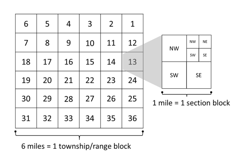
For Example
“The E1/2 of the NW1/4 of Section 17, Township 14 North, Range 4 West of the 6th Principal Meridian.” In this example, the land described would have an area of 80 acres (the NW1/4 equals 160 acres; ½ of this ¼ equals 80 acres). Generally, the smaller a parcel of land is, the longer its legal description will be.
Subdivision Lot and Block:
The second method of land description is by lot and block number in a subdivision plat. When land is subdivided by its owner, the first step is the preparation of a plat map survey by a licensed surveyor or engineer. On this plat, the land is divided into lots and blocks, and streets or access roads for public use are indicated. The lots and blocks are assigned numbers or letters.
Source: “Real Estate Fundamentals, 6th Edition, 2003”. Gaddy Jr., Wade E., Hart, Robert E.